

Travel
Road Trips in Pakistan: Highways Through History
The Karakoram Highway to the Chinese border, the Makran coast to Gwadar, the ancient Grand Trunk Road, the Babusar Pass and the motorways that link it all, with seasons, safety and permits.
- KKH, N-10, N-5, M-2 and Babusar
- Mountain passes: early summer to autumn
- Motorway police helpline: 130
Karakoram Highway, Gilgit-Baltistan
Why Pakistan Is Made for Road Trips
Pakistan's great journeys are best made on wheels. Within a single country you can drive from the Arabian Sea to a border post among glaciers, follow a road that armies and couriers have used for more than two thousand years, and cross passes where snow lingers into summer. The scenery changes with every few hours of driving, palm-fringed coast, desert mountains, irrigated plains, pine forest and finally bare, towering rock.
The network has grown fast. Motorways now link Lahore, Islamabad and Peshawar with smooth, fenced, tolled carriageways, while national highways such as the N-5 (the old Grand Trunk Road), the N-35 (Karakoram Highway) and the N-10 (Makran Coastal Highway) reach the frontiers. Yet much of the magic lies on narrower roads, where landslides, livestock and weather set the pace.
This guide covers the classic routes, when to drive them and how to stay safe. It deliberately gives no fixed driving times: speeds vary enormously with season, roadworks and traffic, so plan generous buffers and check current conditions with the authorities before setting out.
Classic Routes
Five drives every Pakistan road-tripper dreams about.
 Karakoram Highway (N-35)From the plains near Hasan Abdal through Hazara and Kohistan, along the Indus to Gilgit and up the Hunza valley to the Khunjerab Pass on the Chinese border.
 Makran Coastal Highway (N-10)Karachi to Gwadar along the Arabian Sea, past Hingol National Park, Kund Malir beach, Ormara and Pasni, sea on one side, sculpted mud cliffs on the other.
 Grand Trunk Road (N-5)The ancient trunk route of the subcontinent, running through Lahore, Gujranwala, Jhelum, Rawalpindi, Attock and Peshawar towards the Khyber Pass.
 Kaghan valley and Babusar PassThe summer shortcut from Hazara to Gilgit-Baltistan: up the Kunhar River to Naran, past Lulusar Lake and over Babusar Top to Chilas on the KKH.
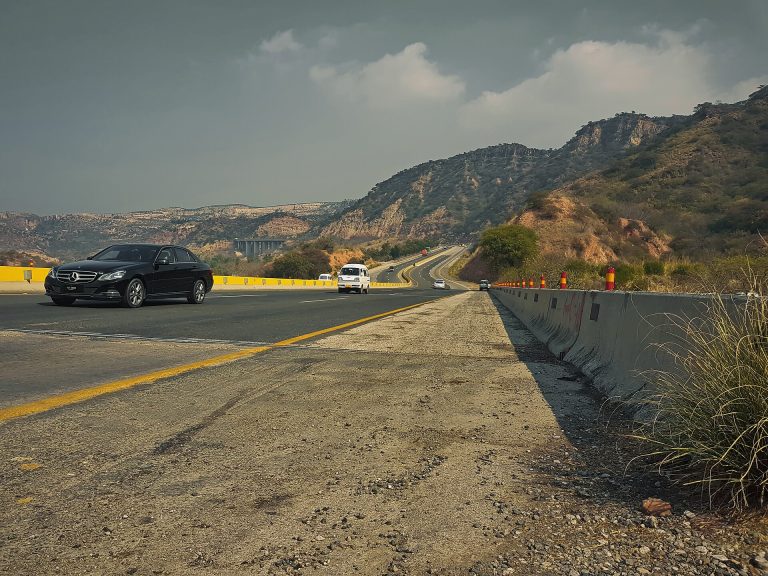 Lahore–Islamabad motorway (M-2)Pakistan's first motorway, inaugurated in 1997, climbs dramatically through the Salt Range near Kallar Kahar and makes a smooth first or last leg for northern trips.
 Chitral and ShandurA rugged loop for experienced drivers: through Dir and the Lowari tunnel to Chitral, then over the Shandur Pass to Gilgit in summer.
The Karakoram Highway
Few roads anywhere carry as much legend as the KKH. Built jointly by Pakistan and China over almost two decades and finished in the late 1970s, it cuts through some of the most unstable mountain terrain on earth; Encyclopaedia Britannica records that around 24,000 workers were involved. On the Pakistani side the highway follows the Indus gorge past the Nanga Parbat massif, then the Gilgit and Hunza rivers, before climbing to the Khunjerab Pass at roughly 4,700 metres.
The road has been reshaped by nature. In January 2010 a landslide at Attabad dammed the Hunza River and drowned a long stretch of highway beneath what is now Attabad Lake. In September 2015 a realigned section with five tunnels, totalling about 7 km, was inaugurated; it was built by the National Highway Authority with China Road and Bridge Corporation.
Highlights along the way
- Views of Nanga Parbat and Rakaposhi, and the confluence of the Indus and Gilgit rivers near Jaglot.
- Karimabad and Altit in central Hunza, then Attabad Lake and the Passu Cones in Gojal.
- Khunjerab National Park and the border post at the pass, where yaks and Marco Polo sheep may be seen.
The Khunjerab border crossing has traditionally closed for the winter; check its current status with the authorities before planning a trip to the top.

The Makran Coastal Highway
The N-10 runs west from the Karachi area along the Balochistan coast to Gwadar. It is one of the most spectacular drives in South Asia, with long views of empty beaches, lagoons and the eroded mudstone pinnacles of Hingol National Park, where the rock formation known as the Princess of Hope stands beside the road. Kund Malir's broad beach is the usual first stop; further on lie the fishing towns of Ormara and Pasni and finally Gwadar's hammerhead peninsula.
Services are sparse. Fuel stations and places to eat are widely spaced, mobile coverage is patchy, and there are security check-posts along the way where you may be asked for identification and details of your journey. Drive in daylight, carry water and a spare tyre, and keep copies of your documents handy. Foreign visitors in particular should check current advisories and local authority guidance, as requirements for travel in coastal Balochistan can change.
The best time is the cool season, roughly November to March. Summer is extremely hot, and the monsoon can bring humidity and occasional flash flooding in the hill streams.

The Grand Trunk Road
Long before motorways, the GT Road was the backbone of the subcontinent, linking Bengal with Kabul. Writing in Dawn, the Lahore historian Majid Sheikh traced its many names, the Mauryan-era route between Taxila and Pataliputra, the Shahi Sarak of the Mughals and finally the British 'Grand Trunk Road'. The Afghan ruler Sher Shah Suri upgraded it in the 16th century with watchtowers and caravanserais at regular intervals, so that couriers could change horses and messages crossed the empire in days.
In Pakistan the road, now the N-5, still threads the major cities of the north: Lahore, Gujranwala, Jhelum, Rawalpindi, Attock and Peshawar. Driving it is a lesson in history. Look for surviving kos minars (milestone towers) near Lahore, the great Sher Shah-era fortress of Rohtas near Jhelum, the old sarai-fort at Rawat outside Rawalpindi, the Mughal fort at Attock above the Indus, and the Buddhist sites of Taxila just off the route.
Traffic is heavy and slow through towns, so many travellers use the motorways for long legs and dip onto the GT Road for its sights.

Babusar Pass and the Kaghan Valley
From Mansehra and Balakot the road follows the Kunhar River up the Kaghan valley to Naran, then climbs past Lulusar Lake to Babusar Top, given by Daily Times as 13,692 feet (about 4,173 m) and some 65 km beyond Naran. On the far side it descends steeply through Diamer district to Chilas on the Karakoram Highway.
Snow closes the pass for much of the year. Dawn reports that the road is usually open from the end of June to October, though early or late snowfall can shut it without warning. The descent towards Chilas is steep and has seen serious accidents involving overloaded vans and brake failure, so use low gears, avoid overheating brakes and travel with an experienced mountain driver if you are unsure. Local authorities have at times restricted travel on the pass in the evening, follow the instructions at check-posts.
When the pass is closed, the Karakoram Highway via Besham and Dasu is the alternative route to Gilgit-Baltistan.

Motorways and Highways
M-2 and the motorway spine
Lahore–Islamabad and beyond
The M-2, inaugurated in November 1997, connects with the M-1 to Peshawar; newer motorways extend south towards Multan and Sukkur.
Tolls and M-Tag
Motorways are tolled. Motorway police have made the electronic M-Tag mandatory at toll plazas, available from booths at the plazas with CNIC, licence and registration papers; check NHA for current rules.
Motorway police
The National Highways & Motorway Police patrol motorways and major highways. Call 130 for help; they also run Radio FM 95 for travel information.
Speed and lanes
Speed limits are posted and enforced by patrols; slower and heavy vehicles keep to the left. Wear seat belts and never use the hard shoulder for overtaking.
Service areas
Motorways have service areas with fuel, food, prayer rooms and toilets, useful rest stops on long days.
Emergencies
Save 130 (motorway police), 1122 (rescue) and 15 (police). Coverage and response vary on remote mountain roads.
Read moreWhen to Drive Where
| Route | Best season | Watch out for |
|---|---|---|
| Karakoram Highway to Hunza | April to October | Landslides after rain and snowmelt; winter cold above Gilgit |
| Khunjerab Pass | Summer to early autumn | Border crossing has traditionally closed in winter; altitude |
| Babusar Pass | Usually late June to October | Snow closures, steep descent to Chilas, evening restrictions |
| Makran Coastal Highway | November to March | Extreme summer heat, sparse fuel, security check-posts |
| Grand Trunk Road and motorways | Year-round | Winter fog in the Punjab plains, summer heat, monsoon flooding |
| Chitral and Shandur | Summer | Rough unpaved sections, river crossings, permits for foreigners |
General guidance compiled from Dawn, Daily Times and official sources, October 2026. Conditions change every year, check NHMP, NHA and provincial authorities before travel.
Safety on Pakistan's Roads
- Drive in daylight on mountain and coastal highways; avoid night driving outside cities.
- In the mountains, use low gears on descents and give way to uphill traffic where the road is narrow.
- Check forecasts and road status before each day; monsoon rain and snowmelt trigger landslides on the KKH and side roads.
- Carry cash, water, snacks, warm layers, a first-aid kit, a spare tyre and a tow rope; fuel up whenever you can in remote areas.
- Keep CNIC or passport, visa, driving licence and vehicle papers ready for check-posts.
- Watch for slow tractors, livestock and vehicles without lights, especially at dusk and in winter fog.
- Ascend gradually on high routes and descend if you feel the symptoms of altitude sickness.
- Hire an experienced local driver or a 4x4 with driver for unpaved routes such as Shandur or the jeep tracks to Fairy Meadows and Deosai.
Permits and Advisories
Pakistani citizens can drive most tourist routes freely, but must carry their CNIC and expect check-posts. Foreign visitors may need a No Objection Certificate (NOC) for some areas, including parts of Khyber Pakhtunkhwa (the KP Tourism Department runs an online NOC system), coastal and interior Balochistan, and areas near the Line of Control in Azad Jammu and Kashmir; police escorts are sometimes arranged. Requirements change frequently, check current advisories and local authority guidance, and your own government's travel advice, before you set out.

Frequently Asked Questions
What is the most famous road trip in Pakistan?
The Karakoram Highway (N-35), which runs from the plains of northern Punjab through Khyber Pakhtunkhwa and Gilgit-Baltistan to the Khunjerab Pass on the Chinese border, at roughly 4,700 metres.
When is the Babusar Pass open?
Usually from the end of June to October, according to Dawn, but snowfall can close it earlier or later. Check with local authorities before setting out; if it is closed, use the Karakoram Highway via Besham and Chilas.
How long does it take to drive from Islamabad to Hunza?
It depends heavily on the route, season, roadworks and landslides, so we do not quote a fixed time. Most travellers break the journey for at least one night, often in Naran or Chilas (via Babusar) or Besham (via the KKH).
Is it safe to drive the Makran Coastal Highway?
Many Pakistani travellers drive it every winter, but services are sparse and there are security check-posts. Travel in daylight, carry supplies and documents, and check current advisories and local authority guidance, especially if you are a foreign visitor.
Do I need an M-Tag to use Pakistan's motorways?
Motorway police have made M-Tags mandatory at motorway toll plazas, and tags can be obtained at booths at the plazas with your CNIC, driving licence and vehicle registration. Rules for foreign and rented vehicles can differ, so check with NHA or your rental company.
Can foreigners drive in Pakistan?
Foreign visitors generally need an International Driving Permit with their home licence, and may need NOCs for certain areas. Many choose to hire a car with a local driver, which also helps at check-posts. See our driving licence guide and check current rules.
Keep Exploring
Related places and stories on DailyLife.pk
 Khunjerab PassKhunjerab Pass guide: the Karakoram Highway border crossing, Khunjerab National Park wildlife, season, altitude safety
 Hunza ValleyPlan a Hunza Valley trip: Baltit and Altit forts, Attabad Lake, Passu Cones, Hussaini bridge
 Naran–KaghanNaran–Kaghan guide: Saiful Muluk, Lulusar, Babusar Top, Shogran and Siri Paye, with road seasons
 Hingol National ParkPlan a trip to Hingol National Park, Balochistan: Princess of Hope, the Sphinx rock
 Kund MalirPlan a Kund Malir trip: the beach, Makran Coastal Highway, Princess of Hope, Chandragup mud volcano
 Rohtas FortExplore Rohtas Fort near Jhelum: Sohail Gate, ramparts, Haveli Man Singh, Shahi Masjid and stepwells
How we know this
- Type Practical guide
- Sources 13 (5 official/academic)
- Reviewed October 2026
- Disputed points None
Rules and fees change, confirm with the official links below before you act.
13 sources
- Karakoram Highway, Encyclopaedia Britannica
- PM inaugurates tunnels on Attabad Lake, Dawn
- Attabad Lake, Gilgit-Baltistan Tourism Department
- Khunjerab Pass opens for 14 days for trade, Dawn
- Mansehra-Naran-Chilas road: a drive through an earthly paradise, Daily Times
- Tourist van accidents on Babusar road, Dawn
- HARKING BACK: Tracing the history of world's oldest highway, Dawn
- November 26, 1997: New motorway opens in Pakistan, Gulf News
- Unregistered vehicles queued after mandatory imposition of M-tag on motorway, Dunya News
- National Highways & Motorway Police, NHMP
- Motorway Helpline Calls Made Free, Pakistan Telecommunication Authority
- Hingol Cultural Landscape (Tentative List), UNESCO World Heritage Centre
- Makran Coastal Highway (used to locate primary sources), Wikipedia
Photo credits (11)
- The beautiful Karakoram Highway.jpg, Saadzafar91, CC BY-SA 3.0, via Wikimedia Commons
- Pakistani truck in Karakoram Highway, Passu, Northern Areas, Pakistan.jpg, katorisi, CC BY-SA 3.0, via Wikimedia Commons
- Attabad Lake, Hunza Pakistan.jpg, Hassanzealous, CC BY-SA 4.0, via Wikimedia Commons
- Khunjerab Pass Road.jpg, Muneeb Qazi, CC BY-SA 4.0, via Wikimedia Commons
- Makran Coastal Highway, Balochistan.jpg, Furqanlw, CC BY-SA 4.0, via Wikimedia Commons
- Hingool Nationa Park and Makran Coastal Highway.jpg, Asad.aman83, CC BY-SA 4.0, via Wikimedia Commons
- GT Road @ Pakistan (15298889327).jpg, Guilhem Vellut from Annecy, France, CC BY 2.0, via Wikimedia Commons
- Rawat Fort - Main Gate East.jpg, Mudabbirmaajid, CC BY-SA 3.0, via Wikimedia Commons
- Babusar Top Gilgit.jpg, King Eliot, CC BY-SA 4.0, via Wikimedia Commons
- View from Babusar top 2.jpg, Saadzafar91, CC BY-SA 3.0, via Wikimedia Commons
- Motorway M2, Salt Range, Pakistan 04.jpg, Shahzaib Damn Cruze, CC BY-SA 4.0, via Wikimedia Commons
